"When you operate in an overbuilt metropolis, you have to hack your way with a meat ax."
- Robert Moses
The fact that I absolutely love maps probably explains why I'm in the process of building a map for Port Henry, home of our superhero game, with far more detail than is required. As a kid, the first things that got my attention in The Hobbit were the excellent maps. I studied New York City subway maps so much that to this day when I visit New York and get asked for directions on the subway I can accurately send them on their way (I stay up to date - I really want to live long enough to see the 2nd Avenue Subway come fully into service).
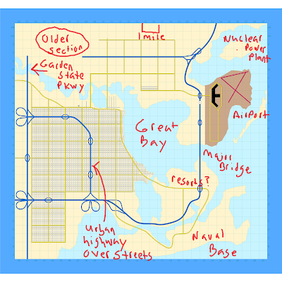
Our game is kicking off in late 1957, after the launch of Sputnik. This is the era of urban planners like Robert Moses. People with good attentions but rather married to the idea that the automobile is the answer (regardless of the question) and any problems with that answer can be solved by more lanes. I've kept that in mind as I sketch a picture of Port Henry. If you click on the map (which is under construction) you'll see it in much greater detail. Being born in the 1970s I have memories of these urban projects - the old Boston Central Artery which hovered above the streets and New York City's West Side Elevated Highway. I remember going to Manhattan with my parents to see the fireworks on the Fourth of July and in our quest we somehow found ourselves walking on a closed down section of the West Side Highway (closed due to an adjacent section having collapsed). I'm really not sure how we got on it - it was 1976 and two months before my fifth birthday so the fact that I have any recollection of it is pretty darn impressive...
 |
| Boston's Central Artery |
 |
| Boston's Central Artery |
The exercise of drawing a map has helped me understand the city that's being created. It's been getting a lot more real. It does mean some research - how big is a city block, where is the city on a grid, how long does a highway entrance ramp need to be, etc. Right now I'm getting impressions of the city... Some of it is still solidifying, so rather than give full details, I'll rattle off what I think I've learned about the city...
- Thor's attack (see earlier posts) on the city in 1947 paved the way for a lot of construction projects. It also left some creepy elves behind...
- The areas under the elevated highways are probably pretty unpleasant. For the parts running directly over streets in a straight line, I'm thinking perhaps the city planners had a horrible idea of making the area a bit of an open-air market/concourse/bazaar/etc. However, it wound up being a rather creepy place during the day and pretty horrible at night. Creepy extradimensional being can be found here...
- The nuclear power plant has not yet come online but is undergoing final testing. The fact that it is really close to the airport is probably a horrible idea. An early draft of the map had one of the runways pointing right at the power plant. I did adjust that at least...
- I've not yet drawn them out, but there's a subway in the city. I'm thinking of a setup with a pretty decent elevated system still in use as they make for great collateral damage in superhero fights.
- I'm thinking there might be an abandoned baseball stadium in the city, what with 1957 being the last seasons the Dodgers and Giants were in New York. A National League team in Port Henry might have gone west with them. Of course that makes it likely that only an American League team remains and I'm a National League fan, liking the idea that everyone bats... We'll see.
- There's a naval base on one of the islands. I don't picture it as an isolated location but rather one with lots of civilian workers and some restricted places.
- I'm not quite certain if there's any beaches in the area - what with all the busy harbor and naval base it might not be the nicest place to go for a swim. Atlantic City is quite close though.
More as the setting develops further and gets inhabited by heroes and villains...


0 Comments